


Krishna River Rises: 7 Belagavi Bridges Submerged
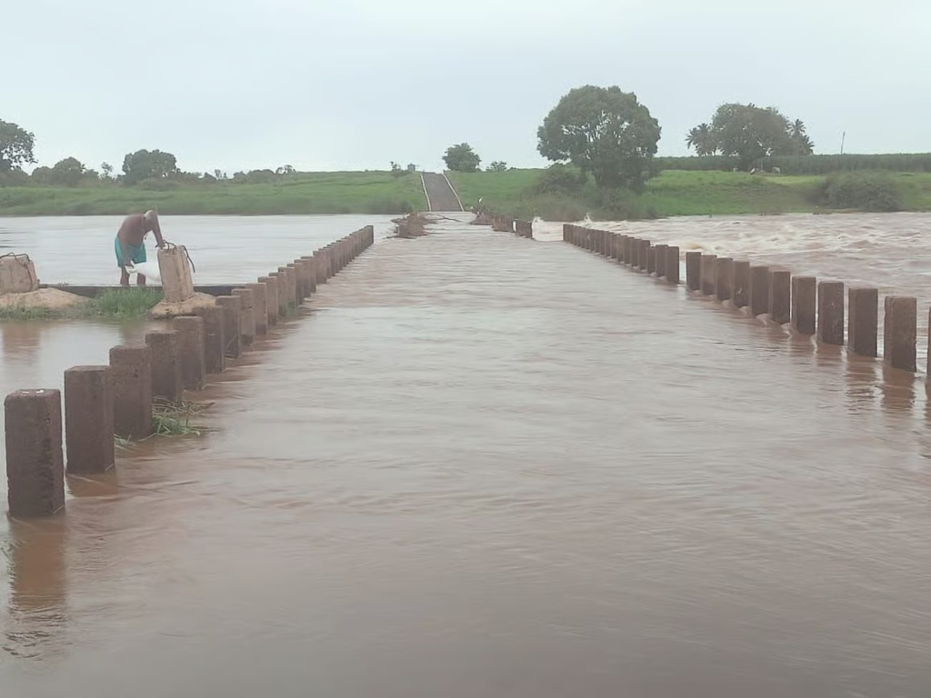
Belagavi: Heavy rainfall now pounds the Western Ghats and parts of Maharashtra. This intense downpour makes the Krishna River’s water levels surge dramatically. The river’s inflow, exceeding 1 lakh cusecs, has triggered immediate flood concerns across Karnataka’s Belagavi district [Internal Link: About Belagavi District]. Consequently, rising waters cause severe disruptions.
For more details : https://pragativahini-com.translate.goog/belagavi-7-bridgeflood-krishna-river/?_x_tr_sl=kn&_x_tr_tl=en&_x_tr_hl=en&_x_tr_pto=sc
Bridges Go Underwater in Chikkodi
Specifically, the swollen river has completely submerged seven crucial low-lying bridges in the Chikkodi region [Internal Link: Chikkodi Local News]. This effectively cuts off connectivity. It also isolates numerous villages and communities. As a result, commuters, local businesses, and daily life have ground to a halt.
The following bridges are now impassable:
- Mallikwad-Dattawad
- Bhoj-Karadaga
- Bharwad-Kunnur
- Bhojwadi-Kunnur
- Akkol-Sidnal
- Yadur-Kallol
- Bhavanasoundatti-Manjari
Impact on Daily Life
Because floodwaters from the persistent Krishna River and its tributaries continue to engulf these vital routes, daily life in the affected villages faces profound challenges. Many residents are stranded. They cannot travel for work, supplies, or medical emergencies. Furthermore, essential services struggle to reach these cut-off areas. In addition, the agricultural sector, a vital part of the region’s economy, is under significant threat as floodwaters inundate fields.
Authorities Respond and Outlook
Local authorities, including the district administration and disaster response teams, closely monitor the situation. They issue advisories and remain on high alert. Officials are prepared to initiate rescue and relief operations if water levels continue to climb. Therefore, they urge locals to exercise extreme caution. Avoid venturing near riverbanks or attempting to cross submerged routes. Moreover, the India Meteorological Department (IMD) forecasts heavy rains in the catchment areas [External Link: IMD Weather Forecast]. This indicates the flood threat will likely persist for the coming days. For real-time water level data, residents can refer to the Karnataka State Disaster Management Authority website [External Link: KSDMA Official Site].
Ultimately, this situation highlights an ongoing challenge for low-lying areas during peak monsoon. It also underscores the crucial need for resilient infrastructure and proactive disaster preparedness. This helps mitigate the impact of such natural events.
Read also :Chikale Falls Reopens to Public Amidst Lingering Safety Worries